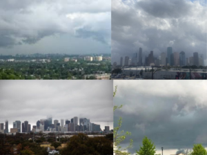

HOUSTON, TX — Houstonians are bracing for another wet afternoon as widespread showers and thunderstorms are forecast to stretch into Tuesday evening, bringing potential downpours, minor street flooding, and slow-moving traffic across the metro area.
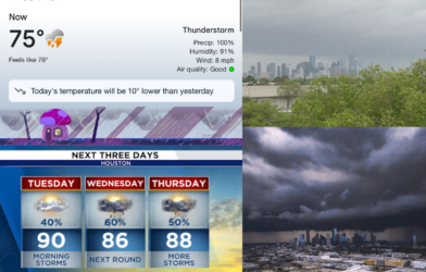
According to the latest weather updates, conditions will remain mostly dry through the morning, but things are expected to shift rapidly by the afternoon. Storm systems fueled by Gulf moisture are set to build throughout the day, especially in areas south of I‑10, with rainfall intensifying between 3 p.m. and 9 p.m.
While most neighborhoods are predicted to receive less than a tenth of an inch of rain, isolated storm cells could dump up to an inch in a short period — raising the risk for waterlogged streets and reduced visibility during rush hour.
Meteorologists say this isn’t a severe weather setup but a classic Gulf Coast summer pattern: hot, humid days followed by pop-up thunderstorms that can pack heavy rain, gusty winds, and occasional lightning.
What to Expect:
• Tuesday Afternoon & Evening: Intermittent thunderstorms with pockets of heavy rain. Peak activity expected between 4–8 p.m.
• Wednesday Forecast: Continued rain chances near 40%, with cloudy skies and high humidity.
• Thursday into the Weekend: Rain tapers slightly but returns by Saturday with another round of scattered storms.
Despite the gloomy outlook, there is no threat of severe weather at this time. However, emergency officials advise drivers to remain cautious and avoid flooded roadways.
Tips for Residents:
• Have umbrellas, ponchos, and rain boots handy.
• Drive slowly and use headlights in poor visibility.
• Monitor local weather apps for real-time radar and warnings.
With temperatures hovering in the upper 80s to low 90s and humidity on the rise, the brief coolness brought on by afternoon storms may be the only relief for now. As always in Houston, when it rains — it pours.