
Houston, TX – June 17, 2025 — If you’re heading out this Monday, make sure to keep your umbrella close at hand. The city continues to experience off-and-on thunderstorms throughout the day, part of a larger system that’s been affecting Southeast Texas over the weekend.
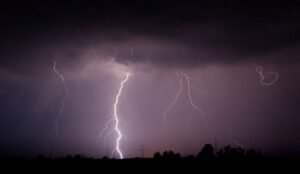
The National Weather Service (NWS) has warned of localized heavy rain, potential flash flooding, and occasional lightning strikes as the storm cells continue to move slowly across the region.
What’s Causing the Storms?
According to meteorologists, a low-pressure system combined with Gulf moisture is creating unstable atmospheric conditions over Houston and nearby counties. These factors contribute to the development of scattered thunderstorms, some of which may intensify with little notice.
Rainfall estimates suggest parts of the city could receive between 1 to 2 inches of rain today, with some isolated areas seeing more. Flash flooding remains a concern, especially in low-lying neighborhoods and areas with poor drainage.
Timing and Impact
The storms are expected to come and go throughout the day, peaking in intensity during the early afternoon and again in the evening hours. While some periods of sunshine are possible in between, don’t expect clear skies to last long.
Commuters should be cautious during peak traffic hours. Sudden downpours could lead to slick roads, reduced visibility, and minor travel delays. Public safety officials are advising drivers to slow down, use headlights, and avoid flooded roads.
Flooding and Emergency Preparedness
The City of Houston’s Office of Emergency Management is keeping a close eye on the situation. While no widespread flooding is currently reported, the ground remains saturated from recent rains, increasing the likelihood of runoff and water pooling.
Residents are encouraged to monitor local weather stations, download emergency alert apps, and prepare for the possibility of temporary power outages in storm-affected areas.
School and Event Updates
As of now, no major school closures or cancellations have been announced. However, outdoor events may face delays or postponements depending on weather severity later in the day. Organizers are urged to have rain plans in place and communicate clearly with attendees.
Looking Ahead
The current pattern may linger into Tuesday, with similar scattered storms forecasted through midweek. A possible break in rain is expected by Thursday, though temperatures are also projected to rise with increased humidity.
Tips to Stay Safe Today:
- Avoid walking or driving through floodwaters.
- Secure outdoor furniture and items that could be blown away.
- Keep electronic devices charged in case of power loss.
- Stay indoors during periods of heavy lightning and thunder.
- Check weather apps regularly for radar and alerts.